 You may not know about The Maine Sculpture Trail but you might have seen a granite statue in an unlikely location somewhere in Downeast Maine. The reality is these sculptures were built over the course of years by world class artists for the towns they now live in.
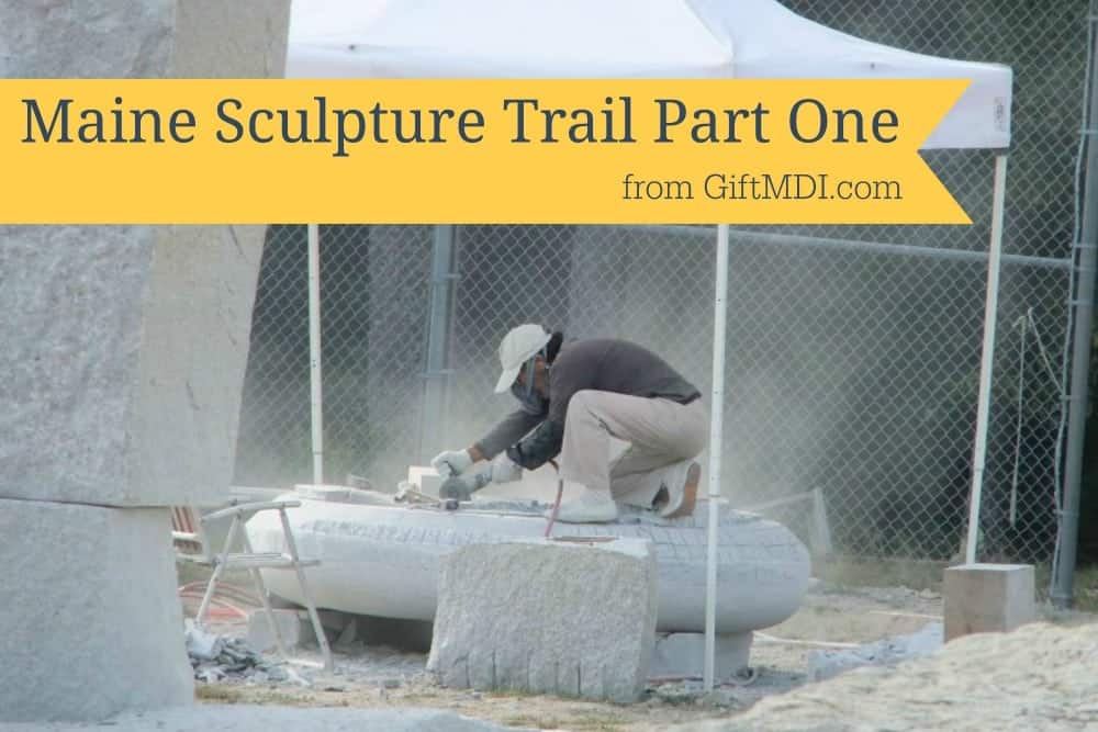
Local Mainer and Steuben native, Jesse Salisbury, a well-traveled sculptor organized a series of symposia (2007, 2009, 2011, 2012, and 2014) called The Schoodic International Sculpture Symposium (SISS) where internationally-known sculptors were invited to complete the fabulous monuments on this trail.
There are many ways you can proceed along the the trail, but the route I like to take is called “Oh Canada” (because you’re headed to Canada) or the seated Welsh Terrier (because it looks like a seated Welsh Terrier when you connect the dots) but you can feel free to call the route whatever you like or map out whatever order you’d like to visit the sculptures in.
This trail is one you can best enjoy while driving. We’ll not the distances from one sculpture to the other in miles for planning purposes.
I like to invite a good buddy along for good road trips. It is important to me to have someone laidback, who enjoys riding along with good conversation and adventure. That’s my good friend Jeremiah to a tee. So I thank you for joining me, Jeremiah, and the rest of our wide readership on this journey. Without further ado, we have the Seated Welsh Terrier route of the Maine Sculpture Trail:
Getting Started
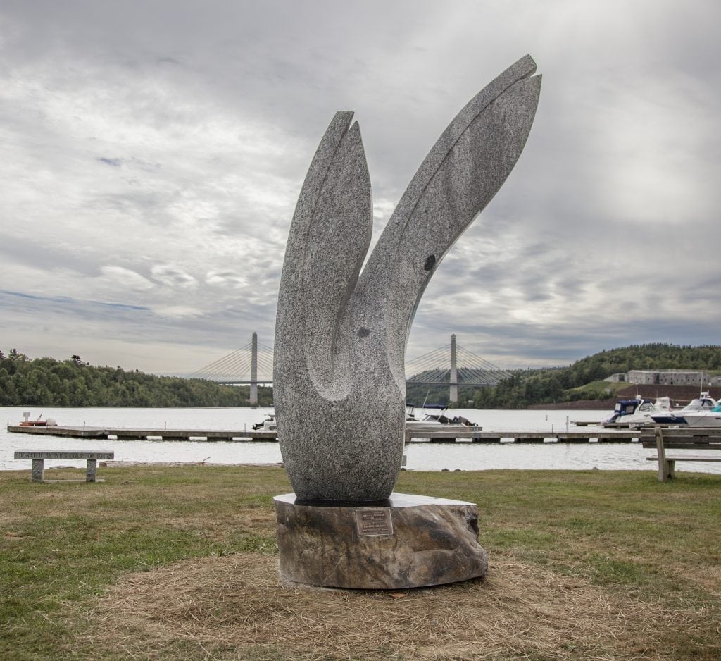
Start off by going on I-95. North or south will naturally depend on your origin spot in relation to Exit 193 to Old Town. We are headed north. Roll down the windows and turn up Jimi Hendrix to get you in the right mood because the first sculpture is named after his famous version of the Bob Dylan classic, “All Along the Watchtower.” Dutch artist Ton Kalle who created the sculpture advises a quiet setting to best hear stones speak. I think it tells the story of the Penobscot River it looks over and all the history that has flowed through and the cyclical nature of the changing of “the establishment” (in the lyrics of the famous song) and has occur so many times throughout this river’s life.

Location:
Binette Park on the Old Town waterfront.
44°56’15.2”N 68°38’46.5”W
4.3 miles
We drive south get an education at the University of Maine in Orono without having to take out any students loans as we park our car before ascending the hilltop of University of Maine to see “Metamorphosis” by Lee Zih-Cing from Taiwan. This piece is a little more uplifting and happy that Kafka’s famous story of the same name. Unlike in Kakfa where Gregor Samsa is transformed into a big beetle or cockroach, here we see the metamorphosis of a butterfly. As the artist explains, “The core idea is ‘live in the present, remember the past and dream about the future.” The round hole in the center of the sculpture appears to be the bridge between these different realms. This butterfly is pleasant company and I am thankful there are no cockroaches around.

Location:
The corner of Rangley and Long roads on University of Maine’s Orono campus.
44°54’12.7”N 68°39’42.1”W
1.3 miles (5.6 miles total on the trail)
No need to drive to the next sculpture as we are going to stay on the University of Maine campus as we take a little walk to the Buchanan Alumni House where we see “A New Dawn” by New Zealand artist Johnny Turner. The meaning of the piece is very much intertwined with the work the Alumni Foundation does in helping to usher students towards a new, exciting phase of their life. The artist notes, “The millions of year old Maine granite and especially the pluton of crystals running through it, are a reminder to us to cherish and celebrate our own short, fleeting lives.”

Location:
College Avenue near the Buchanan Alumni House, which is the campus visitor center.
44°53’42.3”N 68°40’22.7”W
0.4 miles (6 miles total on the trail)
We keep our car parked and stay on foot as we take just a ten minute stroll on the University of Maine campus to Nutting Hall where we see “Line Totem: Man and His Dog Walking into the Forest” by Maine’s very own Tim Shay. There are two fine totem structures where the vertical appears to be the man and the horizontal appears to be the dog.

Location:
In front of Nutting Hall on Grove Street Extension on University of Maine campus.
44°53’47.2”N 68°40’04.9”W
2.6 miles (8.6 miles total on the trail)
We are going to hop into our car and leave the University of Maine campus but stay in Orono for our next location to see “Dragon” by Teng Shan-Chi of Taiwan. This is the closest to a dragon I’ll probably ever get in my lifetime! The sculpture, as the artist explains, is “structured with the Dragon shape, gathered from all directions and extended outwards and upwards.” Now it is onwards and upwards for us as we hop in our car to our next destination.

Location:
In front of the UCU building on the corner of Main St. and Bennoch Rd in Orono.
44°53’01.3”N 68°40’20.2”W
9.8 miles (18.4 miles total on the trail)
From Orono and home of University of Maine we go to another college setting at Husson University in Bangor to view “Lay Down Like Grass” Hwang Seung Woo from South Korea, which is something of cyclical sacrifice and temporary desires that somehow, after their passing, live on in the next generation as a sort of fertilizer or nutrients for the new monuments to grow. And the next monument is across town–we hop in our car and go.

Location:
Near the O’Donnell Commons on Husson University campus.
44°49’40.9″N 68°47’31.1″W
2.3 miles (20.7 miles total on the trail)
Now we go to “Zephyr” at Acadia Hospital in Bangor. The Maine sculptor who made this, Andreas Von Huene states, “Visitors have mentioned seeing the form as representing someone reaching out to help someone in need, as a child reaching for help, a flower, a bird, and an angel.”

Location:
Acadia Hospital on Stillwater Avenue in Bangor.
44°49’13.6″N 68°45’48.6″W
2.1 miles (22.8 miles total on the trail)
You might think Maine is moose country, but the Bangor Waterfront is “The Camel Country” by Japanese artist Koichi Ogino. Are these like camel humps or perhaps a sort of granite oasis rising the from the grass? Or something else?

Location:
Front Street on the Bangor Waterfront.
44°47’44.4″N 68°46’12.4″W
Food Time
At this point we got a little hungry. We grab some grub at one of my favorite restaurants in Bangor and best-kept secrets around: Cubita Libre Cafeteria, serving the best Cuban food available on the Maine Sculpture Trail (Seated Terrier Route or otherwise). I enjoy the steak ropa vieja variety plate and wash it down with a Cuban smoothie while Jeremiah has the best Cuban sandwich ever and we are ready for the rest of the trail.
Back On The Road
18.8 miles (41.6 miles total on the trail)
We head to Bucksport where we see the work of a local Maine artist, Matthew Foster, entitled “Before the Wind.” As the artist states, “For this sculpture, the inspiration came from the people and the landscape of Bucksport. The residents’ sincere wish was for a sculpture for the children of Bucksport, and the generations of tomorrow. With this in mind, I created a piece that reaches back into Bucksport’s maritime history and its connection to the natural world around it.” This piece does appear to connect different worlds with the Penobscot Narrows Bridge in the backdrop as well as many boats still working the waterways of the river.
Location:
Flag Point Park on the waterfront, near the junction of Rte. 1 and Rte. 15, on Main St, within view of the Verona Bridge.
44°34’17.1″N 68°47’41.7″W
17.5 miles (59.1 miles total on the trail)
After a scenic Maine drive, we arrive at The Wilson Museum in downtown Castine. Here we see “Home and Away” sculpted by Robert Leverich. This work is one of my favorites as it overlooks the water. Is it waiting for a vessel to come home? Or is it peering at home itself at the land across the water? And what about the stone pieces themselves, two of which look like waves of water. Afterwards we take a casual stroll around MMA campus and wonder what it would be like to live the life of a sailor.

Location:
The Wilson Museum in Castine.
44°23’01.9″N 68°48’22.8″W
26.9 miles (86 miles total on the trail)
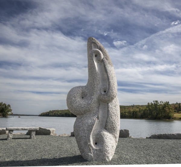
It might be less time and distance as the crow flies, but to get to Scott’s Landing on Deer Isle, we humans can’t go there as the crow flies. But we have a beautiful roundabout route as we cross the Deer Isle Bridge (a fabulous suspension bridge) from the mainland to Little Deer Isle and then the causeway that connects Little Deer Isle to its bigger brother island, Deer Isle. I love crossing the beautiful causeway with the large rocks on either side–even with the guardrails, you still feel incredibly close to the water. And so we these overwhelming beauty around us we go to see “Deer Isle Project” by Attila Rath Geber up on the hill. This work is almost framing a view, sizing it up for a photograph. I’m sure many people have taken photos of this beautiful view this work has set up for us.

Location:
Scott’s Landing on the hill to your left just after the causeway from Little Deer Isle to Deer Isle.
44°16’39.8″N 68°40’35.2″W
14.5 miles (100.5 miles total on the trail)
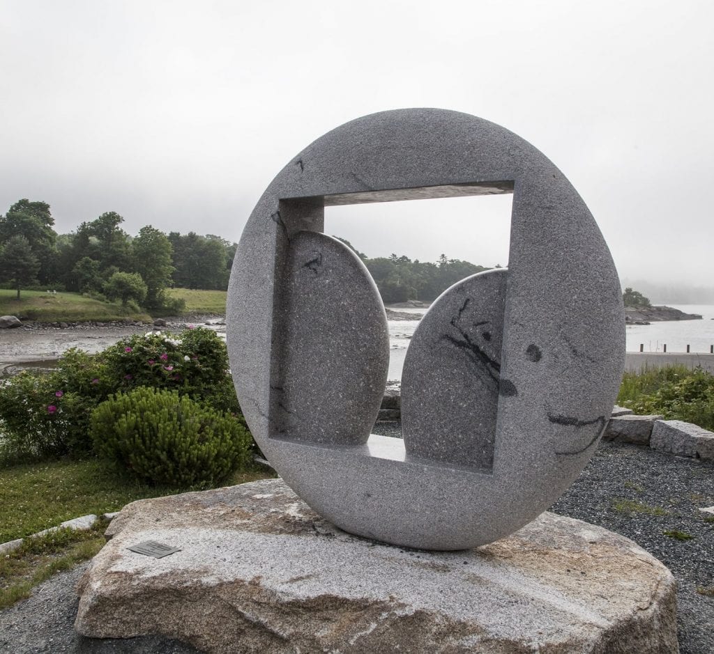
Next up is Emerson Park in Blue Hill, where we see one of the finest sites on this grand peninsula, “The Window of the Sea Wind” by Hitoshi Tanaka of Japan. This reminds me of its Deer Isle Project counterpart, except more symmetrical. Everything, things we see and things we cannot, passes through this “Welcome Window” of Blue Hill.
Location:
Emerson Park at the Blue Hill town landing.
44°24’45.4″N 68°35’11.1″W
7.5 miles (108 miles total on the trail)
Now we travel up the coast towards Surry. Here we discover “Wave Sounds” by Bertha Shortiss from Switzerland. This piece looks like the how the ocean sounds if that is possible. It is impressive and roaring upwards, but with the roundness of the ocean’s slow tumble of rocks. This is an awe-inspiring yet calming piece at the same time. Afterwards I like to stop by Surry Gardens and walk around and pleasantly enjoy the assortment of flowers, plants, and herbs.
Location:
Surry town landing off of Wharf Lane.
44°29’37.3”N 68°30’03.9”W
6.7 miles (114.7 miles total on the trail)
The next town over from Surry is Ellsworth where we see “I Want to Ride a Cloud” by Narihiro Uemura from Japan. And who doesn’t want to ride a cloud? The figure has its arms up in the air like it is indeed riding a cloud and enjoying it with all the exhilaration or a rollercoaster or another theme park ride. I associate clouds with imagination like in the Joni Mitchell song, “Both Sides Now” where clouds can angel hair, ice cream castles, or feather canyons (though I prefer them to be ice cream castles naturally). And if a cloud be one of those things, it certainly could also be a vehicle one might be able to ride like a rocket ship of some sort.

Location:
On State Street in Ellsworth, between the Ellsworth public library and the intersection of State and Main streets.
44°32’29.8″N 68°25’30.7″W
Food Break
While I certainly do want to ride a cloud, I also want to eat at one of my favorite restaurants around: Manny’s Greek Grill, in the Mill Mall in Ellsworth. I eat a Gyro there and Jeremiah gets the Greek plate. We share an order of the Greek fries–I could have eaten them all by myself as they are so delicious. We exchange some like banter with Manny himself before heading on with our journey well-nourished with delicious Greek food.
But which direction? As Ellsworth is a crossroads town that can either lead us further up the coast or towards MDI you do have a choice if you could continue Downeast at this point or go see the sculptures on MDI. Our choice is to move onwards to MDI because it makes the most logistical sense at this point and also we want to conclude are journey by crossing the border into Canada and eating some chocolate. But will we get to that later. For now, we head towards MDI and into Bar Harbor.
Back On The Road
20.2 Miles (134.9 miles total on the trail)
On our way into Bar Harbor we stop for gas at Steamboat Landing on the head of MDI. This is my favorite gas station as they have a custom-made wooden M&M dispenser that dispenses free M&Ms. The next sculpture is “Tension” by Turkish artist Songul Telek and it’s located right near the Bar Harbor Post Office. Now you might have felt tension on your way here if you were battling tourist traffic. Or you might have felt tension if this is the winter and you were were trying to stay on the road amidst rugged conditions. But all the tension in made can easily be wiped away by the beauty of the scenery. As the artist explains: “My sculpture consists of two different structures. While moving in opposite directions they create a tension and being together they stay in balance.”

Location:
Barker Park on Cottage Street next to the Bar Harbor post office.
44°23’22.8″N 68°12’27.2″W
It has been a long day and it will be dark soon, so we decide to stop in at the Black Friar Inn and enjoy a nice dinner and drink as we watch live music. We then go up and further relax on the rooftop porch gazing at the stars before we get some shuteye in one of their cozy rooms.
Stay tuned for parts 2 and 3 of the Maine Sculpture Trail!